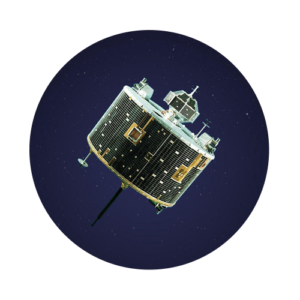
The RADARSAT Constellation Mission (RCM) is a Canadian satellite constellation developed by the Canadian Space Agency (CSA) to provide enhanced radar imaging for various applications, including maritime surveillance, disaster management, and environmental monitoring.
Launched in June 2019, the RCM represents a significant advancement in Canada’s space capabilities, offering improved coverage, resolution, and revisit rates compared to its predecessor, RADARSAT-2. With its three identical satellites working together, RCM delivers comprehensive and timely information to support a wide range of users, from government agencies to commercial entities and research institutions.
History & Evolution
The RCM project originated as a continuation of Canada’s RADARSAT program, which began in the 1990s with the launch of the original RADARSAT-1 satellite. Over the years, the RADARSAT program evolved, leading to the launch of RADARSAT-2 in 2007, which significantly improved imaging capabilities.
Building upon this legacy, the RCM project was initiated to enhance Canada’s radar imaging capabilities further. The development of the RCM constellation involved collaboration between the Canadian Space Agency, the Canadian government, and the Canadian aerospace industry. After several years of design, construction, and testing, the RCM satellites were successfully launched into orbit in June 2019 aboard a SpaceX Falcon 9 rocket.
Mission Objectives
The primary goal of the RADARSAT Constellation Mission is to provide reliable and timely radar imagery of Canada’s vast territory and other regions of interest around the world. Specific mission objectives include enhancing maritime surveillance, monitoring changes in the environment, supporting disaster management efforts, and facilitating scientific research in areas such as climate change and natural resource management.
By offering high-resolution, all-weather imaging capabilities, RCM aims to improve decision-making processes in various sectors, including agriculture, forestry, transportation, and national security.
Infrastructure and Facilities
The RADARSAT Constellation Mission utilizes various infrastructure and facilities, including satellite control centers, ground stations for data reception and processing, and communication networks for transmitting data to end-users. The CSA operates ground stations in Canada and around the world to ensure continuous coverage and data availability. Additionally, the RCM program involves partnerships with international organizations and agencies to leverage their resources and expertise in satellite operations and data analysis.
Spacecraft and Vehicles
The RADARSAT Constellation Mission comprises three identical satellites: RADARSAT-2, which was launched in 2007; and the two newly launched satellites, collectively referred to as RCM-1 and RCM-2.
These satellites are equipped with synthetic aperture radar (SAR) instruments capable of capturing high-resolution radar images of the Earth’s surface. The RCM spacecraft are launched into orbit aboard SpaceX Falcon 9 rockets, providing cost-effective access to space.
Achievements and Discoveries
Since its launch, the RADARSAT Constellation Mission has made significant contributions to various fields, including environmental monitoring, disaster response, and natural resource management.
Its advanced radar imaging capabilities have enabled the detection of changes in sea ice, vegetation, and land use, supporting efforts to address climate change and biodiversity conservation.
Moreover, RCM data has been instrumental in disaster relief operations, providing crucial information to aid in the response to events such as floods, wildfires, and oil spills. Overall, the RCM program has demonstrated Canada’s leadership in space-based Earth observation and its commitment to leveraging space technology for the benefit of society.
Current Status of this program
As of 2024, the RADARSAT Constellation Mission continues to operate successfully, providing valuable radar imagery to users worldwide. The constellation’s three satellites work together to ensure comprehensive coverage and timely data delivery, supporting a wide range of applications in government, industry, and research. With ongoing advancements in satellite technology and data analytics, the RCM program remains at the forefront of Earth observation, contributing to our understanding of the planet and its changing environment.